VisualGIS
VisualGIS is an ArcGIS extension that integrates the GIS environment with
the VisualWorks Digital Video System.
VisualGIS is a combined development between Wish Software and
VisualSoft
- the market leader in Subsea Digital Video products.
VisualGIS is a complete solution for viewing integrated survey data and
digital video from subsea inspection surveys. Integrating GIS and the
VisualWorks digital video system, VisualGIS allows the user instant
accessibility to all survey datasets via an intuitive user interface.
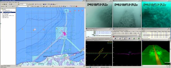
VisualGIS provides a persistent bi-directional link between the GIS and
survey data meaning that the current location in the GIS and the data
displayed in the survey/video windows are always synchronised.
For example, select a pipeline in the GIS and VisualGIS will load the
appropriate survey. Choose an event in the VisualGIS Event Table window and
all the survey/video data windows as well as the current cursor location in
the GIS will be updated appropriately.
 Watch VisualGIS in action
For further information on the VisualSoft VisualWorks suite please visit
http://www.f-e-t.com/visualsoft