|
|

|
FR603 - Calculate E/N File |

|

|

|

|

|
||
|
FR603 - Calculate E/N File |
|
|
|
|

|

|
FR603 - Calculate E/N File
|
|
|
FR603 - Calculate E/N File |
|
|
|
|
|
||
|
FR603 - Calculate E/N File |
|
|
|
|
|
|
The Calculate E/N File Command now includes the option to import a file consisting of Kp and DCC (Offtrack Distance) and to use both of these values along with the selected Route polyline to calculate the Easting/Northing and Latitude/Longitude of each record. The standard convention of negative DCC being to the left or port of the Route is used.
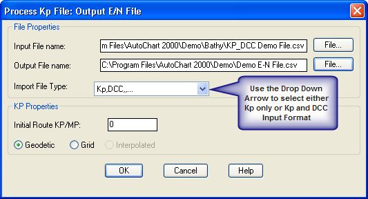
If the Kp only format is used then the calculated positions will be on the selected Route Polyline (i.e. DCC = 0)